At seven-thirty on a damp spring morning, I stood on the ridge above the Kettle with a pair of binoculars, a legal pad, and a cup of coffee gone cold in my hand, and watched strangers build a neighborhood on my land.
Not next to my land. Not near my land. On it.
Below me, bulldozers moved through the valley floor in bright yellow arcs, shaving topsoil, flattening bottom land, and carving neat future streets through pasture my family had owned since 1931. A grader backed over a section of creek-side grass where my grandfather used to set mineral blocks for cattle.
Dump trucks hauled in fill dirt by the load and spread it across ground that had flooded every spring for longer than anybody living could remember. Survey flags snapped in the breeze. Fresh stakes marked property lines that did not exist. And at the far end of the valley, beyond the churned mud and concrete forms, the old earthen dam my grandfather built in 1958 held sixty acres of still water in a patient blue curve against the hills.
That dam was the only reason any of the ground below it looked dry enough to build on.
The people working in the valley did not know that. Or they had not bothered to care.
My name is Colton Pace, and if there is one thing the Pace men before me understood better than most people, it was the difference between what looks stable and what actually is. My great-grandfather Emmett bought those 312 acres in Upper East Tennessee when the country still had more mules than paved roads. The land followed Stony Fork Creek down into a broad bowl of bottom ground locals called the Kettle because it sat low, rounded, and wet under the surrounding ridges like something built to collect weather. Emmett farmed around that reality. Tobacco and corn when the timing worked. Cattle on the uplands. Late planting after heavy springs. Early harvests when he could get them. He did not romanticize land. He read it, respected it, and never confused ownership with control.
My grandfather Dale was different in one important way. He believed some kinds of land could be improved if you were willing to understand water instead of merely cursing it. In 1958, with help from the Soil Conservation Service and more sweat than any of the paperwork fully captures, he built the dam across the narrow southern gap where the valley drained out. Compact clay core. Stone-armored spillway. Reinforced concrete outlet pipe with a manual gate valve. It took two years, and when it was done, the Kettle changed. The reservoir spread wide and shallow. Flood pressure eased. Pasture stayed usable longer. Cattle had reliable water. The spring swamps became manageable ground. Not because nature had changed its mind, but because my family had chosen to hold the creek back and assume the work and liability of doing so.
Every document tied to that dam was recorded.
Every maintenance log. Every engineering plan. Every permit. Every survey.
The dam sat on Pace land. The reservoir sat on Pace land. The valley below it sat on Pace land. There was no uncertainty in any of that, not legally, not historically, and not physically unless a person was willing to close both eyes and call it vision.
My father Roy inherited the property in 1989 and maintained it with the same stubborn seriousness his father had shown. He inspected the spillway, cleared brush, cycled the gate valve, and treated the whole system the way a pilot treats an aircraft that has already saved his life more than once: with gratitude edged by discipline. He died in 2016. I was thirty-one, working as a civil engineer in Kingsport, and in the span of one probate file became the owner of the largest private tract in the township.
By then Ridgeline Estates had already grown up to the north and east like a suburban vine.
It started in the early 2000s as a quiet retirement cluster on higher ground. Then it got a clubhouse, a pool, HOA rules, architectural standards, landscaping mandates, and the sort of aspirational branding that turns a rural place into a brochure. By 2016 it had more than 160 houses and a homeowners association run by a woman named Connie Dressler, who had moved down from Charlotte for mountain air and discovered she preferred control. Connie was one of those people who mistook familiarity for entitlement. Give her a committee and she started behaving like a county government.
The first sign of trouble arrived in the spring of 2018 in a plain county envelope.
Inside was notice from the Carter County Planning Department that a preliminary plat had been filed for Ridgeline Estates Phase Three: seventy-nine residential lots on approximately 210 acres described as adjacent to and south of the existing development.
I read the legal description three times.
Then I went to the file cabinet, pulled my survey, and laid the county notice beside it.
The lots weren’t adjacent to Ridgeline. They were in the Kettle.
My Kettle.
Every neat cul-de-sac on that plat cut across my lower pasture, my creek bottom, the floodplain below the dam, and a long strip of hardwood edge that had never belonged to anyone named Dressler or Winslow or Ridgeline anything. One of the proposed streets was called Pace Meadow Lane, which would have been almost funny if it had not been so brazen.
I drove to the planning office the next morning.
The clerk brought me the plat. Professionally drawn. Clean line work. Licensed surveyor’s seal. Developer signature. The developer’s name was Burl Winslow, which made the rest of the story easier to understand because Burl was Connie Dressler’s son-in-law and ambition tends to travel through families that way.
I asked to see the title description behind the survey certification.
That was where the fraud began to smell strong enough to identify.
The parcel number referenced in the filing belonged to a fifty-acre tract my great-grandfather had sold in 1947, except that tract sat three miles east of the Kettle and had nothing to do with my property. The surveyor, Grady Felts, had certified boundaries matching the developer’s description without checking the real deed chain. The planning office had accepted the filing without cross-referencing county tax records or actual ownership. On paper, one parcel number. On the map, my land. They had filed for one tract and started plotting another.
I pointed it out. The clerk said she would flag it for review. I asked when the review would happen. She said her supervisor was on vacation.
That afternoon I called Frank Wilder.
Frank had handled my father’s estate. Property lawyer out of Johnson City. Dry voice. Good eyes. The sort of man who could read a deed the way carpenters read grain. I told him what I had found. He was silent long enough for me to picture him leaning back in his chair with one hand over his mouth.
Finally he said, “Colton, that’s either the dumbest clerical mistake in Carter County history or the most brazen land grab I’ve seen in twenty-eight years.”
Then he told me the thing most people never tell angry clients.
“Do nothing. Yet.”
No threats. No calls to the developer. No public outrage. No emergency filing in the first afternoon heat of discovery. Document everything. Pull the full title chain. Let him verify the legal spine before we moved muscle.
So I waited.
I photographed survey stakes and recorded GPS points. I saved every filing, every notice, every county response. I drove the ridge line each morning and watched the construction accelerate. This was not the timid kind of building where someone tests soil and hopes nobody objects. This was conquest. Dozers cut a road through the lower pasture. Crews flattened hardwoods. Concrete trucks rolled in before the summer solstice. Foundations appeared where spring water used to stand four feet deep in wet years.
Watching strangers rearrange your land is a specific kind of violation.
It feels domestic and violent at the same time, like coming home to find somebody has moved the walls in your house and is explaining it to guests as an upgrade.
Frank pulled the title chain and confirmed what we both knew. The physical land being built on belonged to me through an unbroken line reaching back to 1931. The parcel number in the plat belonged to somebody else entirely. The surveyor had effectively created a false paper bridge between unrelated tracts of land and invited county planning to treat that bridge as load-bearing.
We had grounds for an emergency injunction.
Frank said so plainly.
A judge would have seen the discrepancy, the unauthorized grading, the lis pendens we could file, and construction would likely stop within days. Buyers would lose deposits or recover them. The developer would take a financial hit. There would be grumbling. Connie Dressler would almost certainly perform victimhood at a public hearing. But the damage would still be in the hundreds of thousands, maybe a low seven figures if everyone got dramatic.
I asked Frank what would happen if I waited.
He looked at me for a long time.
“You understand what you’re asking,” he said. “If you let them build, the damage gets much bigger.”
“No,” I said. “The consequences get more accurate.”
That is an ugly sentence. I know that. It sounds colder on paper than it felt in my chest. There were buyers involved, future homeowners with children and mortgages and reasonable assumptions about how property law was supposed to work in a civilized county. I did think about them. But I also knew how this would play if I stopped it too early. Burl would call it a dispute. Connie would say the paperwork was complicated. The county would hide behind process. The surveyor would shrug and blame a title description. Everyone would move on bruised, embarrassed, and largely intact.
I did not want embarrassment.
I wanted the truth to become too expensive to disguise.
By late August, forty-three of the seventy-nine lots had been sold in presale. Retirees. Young couples. Families escaping bigger cities. They put down deposits and secured loans on houses that did not yet exist on land the developer never owned. Frank filed the quiet title action in July and recorded the lis pendens so anyone doing a competent title search later would see a red flag. But developments move faster than caution when money smells easy. The houses kept rising.
And Connie kept marketing.
That woman sold audacity with sweet tea.
By fall she had a model home on Lot 12: craftsman façade, wraparound porch, brochure racks in the foyer, drone footage looping on a screen in the living room. She handed out glossy pamphlets describing Phase Three as a lakefront community with unmatched natural beauty, walking trails, fishing access, and planned kayak launches. Lakefront. Her brochures were selling my family’s reservoir as an amenity to strangers. She installed a kayak rack on my shoreline. Mowed a path down to the water. Put up a sign reading RIDGELINE ESTATES COMMUNITY LAKE – RESIDENTS ONLY with her phone number beneath it, as if sheer formatting could annex 60 acres of water.
I did not blame the buyers.
Not once.
The people moving into those houses had no reason to suspect the legal floor beneath them was fake. They trusted licensed surveys, county approvals, title companies, real estate agents, HOA documents, and the general American assumption that a neighborhood with mailboxes and a model home probably sits on land somebody bought lawfully. Their innocence mattered to me. It just did not change where my obligation lay.
My obligation was to the truth, the land, and the generations of work underneath both.
Frank and I kept building the file.
He obtained the original Soil Conservation Service engineering records for the dam. They showed exactly what my grandfather built and exactly where: the dam, the reservoir, and the floodplain downstream all within Pace boundaries. We pulled FEMA maps and learned something that turned a bad fraud into a breathtaking one. The Kettle was designated a special flood hazard area, Zone AE, even with the dam in place. The valley below qualified as buildable in practical terms only because my family had maintained flood control there for sixty years. Without the dam, the ground didn’t merely get damp. It reverted to its natural function: seasonal flooding, standing water, spring saturation, and flow paths cutting directly through what Burl was now calling Crescent View Drive.
Then came the line Frank spoke that stayed with me longer than anything else.
“You don’t just own the land under those houses,” he said. “You own the reason it’s habitable.”
He was right.
That mattered more than the deed.
The developer had not just trespassed. He had relied, without permission or inquiry, on private flood protection he did not own, did not maintain, and legally had no right to assume would exist forever. He saw flat land and a pretty reservoir and decided nature had been permanently domesticated because it looked convenient on a plat.
That winter I spent three days in the records room in Elizabethton, pulling every county document tied to my family’s land, the dam, Ridgeline, and the people around it. The deeper I went, the uglier it got. Grady Felts had not merely used the wrong parcel number. He had used a parcel reference belonging to land that had been subdivided and resold multiple times since 1947. By the time he filed the plat, the tract was a tree farm owned by a Baptist church outside Erwin. There was no innocent geographic confusion available to him. The description and the map belonged to different worlds.
I also found a comment letter from the NRCS, successor to the old Soil Conservation Service, warning the planning department that the proposed development lay within a dam inundation zone and recommending a hydrological review before approval.
The county had received it.
Filed it.
Ignored it.
A second document was almost as revealing: a letter from Connie Dressler on official HOA letterhead personally endorsing Phase Three and vouching for Burl Winslow as a trusted development partner. She signed it as HOA president. Later, through a board member named Reggie Wallace, I confirmed the HOA board had never voted on the endorsement. Connie had offered the association’s institutional blessing to her son-in-law’s land grab without authorization, because that is what people like Connie do when they have mistaken proximity to procedure for ownership of it.
By the first months of 2019, my preparation had become methodical enough to feel almost ceremonial.
First I hired Hal Brevard, a dam safety engineer out of Knoxville who had inspected hundreds of structures across Tennessee. He performed a full assessment of the Pace dam and produced a downstream inundation analysis. His report confirmed what family history already knew: the dam was structurally sound, the spillway functioned, the gate valve was operable, and if the reservoir were deliberately drained or the structure decommissioned, the Kettle would return to broad predictable flooding. Depths of three to six feet across the developed area in ordinary high-water cycles. Enough to flood basements, undermine foundations, and render the homes effectively uninhabitable without private flood control.
Second I commissioned a fresh boundary survey from Beth Ann Crow in Kingsport, a surveyor with no ties to anybody in Carter County politics. She walked every line with GPS, set new pins, and produced a certified plat so precise it made the Ridgeline version look like children’s fiction. Seventy-nine lots. Seventy-nine homes. Every one of them inside my boundary lines.
Third, Frank filed a complaint with the state board against Grady Felts for fraudulent certification.
Fourth, he amended the quiet title action to name every serious party: Burl Winslow, Grady Felts, Connie Dressler, the Carter County Planning Department, and the title company issuing policies on the lots.
Fifth, I filed a formal decommissioning notice with Tennessee dam authorities stating my intent to cease active impoundment and open the low-level outlet valve, supported by Hal Brevard’s engineering analysis and downstream notification plan.
That part made some people uncomfortable when they later learned it. They imagined I had secretly concocted a revenge flood in the dark. I didn’t. I followed procedure. Filed notices. Obtained review. Completed the paperwork months before the ruling. The law recognized what was always true: the dam was a private structure on private land. Maintaining it forever for the benefit of trespassers was never my duty.
Sixth, and hardest, I walked the neighborhood.
All of it.
Every new street. Every young maple planted by a mailbox. Every bicycle leaning against a garage door. Every porch chair. A retired couple on Lot 31 had planted roses along their walk. A little boy on Lake View Court had drawn chalk rockets on the driveway. Someone put a wooden bench facing the reservoir and posted a sunset photo in the community Facebook group with the caption Blessed to be home.
I saw all of that.
It mattered.
These were not villains. They were victims with landscaping. But sympathy for the deceived is not a legal surrender of title, and it is not a reason to reward the people who deceived them by letting the fraud calcify into permanence.
By May 2019, seventy-three of the seventy-nine homes were occupied. The remaining six were nearly finished. Ridgeline Estates Phase Three had its own entrance sign, mailbox cluster, recycling schedule, and neighborhood Facebook group. Connie had absorbed the entire section into the main HOA, raised annual dues, and appointed herself chair of a “lake and recreation” subcommittee built around managing access to water she did not own on land she did not own protected by a dam she did not own.
That level of confidence is almost spiritual.
Then the court date arrived.
June 19, Circuit Court of Carter County, courtroom B.
I wore the charcoal suit my father bought me for college graduation. Frank wore navy and carried a briefcase that looked old enough to vote. Burl Winslow arrived with two Nashville attorneys in expensive shoes and expressions arranged somewhere between patience and disdain. Connie sat in the gallery in a cream blazer, arms folded, face set like she was attending the trial of a rude weather system.
Judge Raymond Tuttle took the bench exactly on time.
Frank later told me that what wins cases is rarely brilliance. It is structure. That day he built structure the way my grandfather built the spillway, one stone set against the next until the flow has nowhere to go but where you want it.
He showed the court the two plats side by side: the developer’s, tied to the false parcel reference, and Beth Ann Crow’s certified survey of the Pace property. On the screen, every cul-de-sac and lot line in Phase Three sat cleanly inside my boundary. The parcel Burl claimed and the land he built on were three miles apart. No overlap. No ambiguity. No decent explanation.
Then came the title chain. Then the dam engineering file. Then Hal Brevard’s inundation analysis. Then the ignored NRCS letter. Then Connie’s endorsement on HOA letterhead. Then the board minutes proving the HOA had never approved that endorsement.
The Nashville attorneys objected often and effectively not at all. Judge Tuttle overruled them with the patient irritation of a man who had read the file and did not appreciate time being wasted pretending unread pages might save anyone.
At one point he asked to see Grady Felts’s field notes.
His attorneys didn’t have them.
He made a note.

At another point he read Connie’s endorsement letter aloud into the record. I did not look back at her while he did it, but I heard the shift in the gallery when homeowners realized the development they thought had been properly integrated into the existing community had actually been pushed through on one woman’s unauthorized assurance and a son-in-law’s appetite.
The hearing ran four and a half hours.
When it ended, Tuttle said he would issue a written ruling within fourteen days.
I walked out into the June heat with my jacket over my arm, stood on the courthouse steps, and stared at the town. Frank came beside me, loosened his tie, and said only one thing.
“That judge read every page.”
The ruling came down July 2.
Thirty-one pages.
Methodical. Exact. Merciless.
Judge Tuttle declared that the seventy-nine lots comprising Ridgeline Estates Phase Three sat on land owned by Colton Pace through an unbroken chain of title dating to 1931. He found the plat invalid, the survey deficient and fraudulent, the county negligent in approval, and the HOA endorsement materially improper. He vacated the plat, halted all further construction, and referred aspects of the matter for criminal fraud review.
By afternoon the story hit the Johnson City Press. By evening it was on Knoxville television. The headline wrote itself.
JUDGE RULES 79 HOMES BUILT ON WRONG MAN’S LAND.
What happened next was never impulsive.
It only looked that way to people who had not been paying attention.
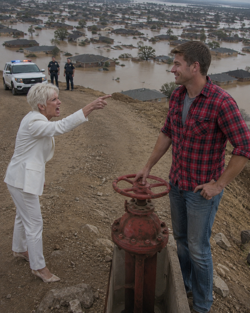
I went to the dam on the morning of July 5 with Hal Brevard present, a county observer, and a copy of every notification we had filed. The reservoir was full from spring rain. The spillway ran silver and steady. The gate valve wheel felt exactly the way I remembered it from helping my father test it as a boy: resistant at first, then willing.
I put my hand on the metal and thought of my grandfather.
Not as avenger. As builder.
Then I opened the low-level outlet.
Not all at once. Not recklessly. Gradually, correctly, exactly the way water should be managed when you respect what it can do.
Over the next seventy-two hours, sixty acres of impounded water drained through the outlet and down Stony Fork Creek’s original path, directly through the heart of Phase Three. No dramatic wall of destruction. No movie surge. Just the return of hydrology to a place where people had built fantasy on borrowed flood control.
The lowest lots took water first.
Then the streets.
Then crawl spaces, basements, and garages.
Three feet in some places. Two in others. Standing brown truth where brochures had promised lifestyle.
The photographs went national. Drone footage showed the emptied reservoir basin above and the flooded subdivision below, connected by the old creek line like a diagram drawn by nature for anyone still confused. Connie’s kayak rack floated sideways near the old shore. Cars sat half-submerged in driveways. Moving trucks bogged in mud. Seventy-nine homes discovered what a floodplain looks like when the man holding back the flood stops doing it for free.
The county declared a local emergency. FEMA assessed. The Weather Service confirmed there had been no unusual rainfall. The flooding resulted from the controlled release of a privately owned impoundment under lawful decommissioning procedures.
That sentence mattered.
Frank gave the only public statement we ever allowed. He explained that I had exercised my legal right to cease maintenance of a private dam on private land in accordance with Tennessee law and regulatory notice requirements. “The valley is returning to its natural hydrological state,” he said. “The water is doing what it has always done. The only thing that changed is that Mr. Pace stopped holding it back.”
For about a week after the water moved through, my phone never stopped ringing.
Reporters. Neighbors. Distant cousins who had never cared much about the land until it became a headline. Men who wanted to tell me what they would have done faster, louder, meaner. Women from church circles asking if I could not have found a gentler path, as if gentle had not been available months earlier when a developer first put survey stakes into my pasture and an HOA president started marketing my reservoir as a community feature. I answered none of them. Frank handled the press. I handled the gate, the paperwork, and the stream of vehicles arriving to inspect what truth looks like once it has soaked into drywall.
The strangest visitors were the homeowners.
Not all at once. One or two at a time, usually after the TV trucks left for the evening and the ridge roads got quiet again. Some came angry because anger is easier to carry than humiliation. Some came exhausted, carrying folders full of closing documents and title policies like paper could still behave like protection if they held it tightly enough. A retired couple from the first cul-de-sac brought me a plate of store-bought cookies and apologized for fishing in my reservoir. They had honestly believed the HOA owned shoreline access because the brochure said so and because there was a sign with Connie’s phone number on it and because most people are trained to trust anything that looks official. I invited them onto the porch, made coffee, and walked them through the title chain as gently as I could. By the time they left, the wife was crying from equal parts embarrassment and rage.
One afternoon, a man named Luis Herrera showed up with his teenage son and a contractor’s laser level in the back of his truck. He had bought one of the last completed homes and had spent three weekends landscaping the yard himself. He stood on the porch, hat in both hands, and asked me the question that seemed to hurt him most.
“Did you know we were down there while they were building?”
“Yes,” I said.
He took that in, swallowed once, and nodded. “Then why didn’t you warn us personally?”
That deserved an answer. So I told him the truth. I told him I could have stopped the project early, but that stopping it early would have protected the wrong people. I told him his anger belonged with Burl, Connie, Grady, the county, and every title professional who failed to do the boring work that keeps families from buying houses on stolen ground. I told him my warning would have sounded like one man shouting against false paperwork, sales agents, county approvals, and HOA assurances. Then I told him something else. “You were never the target,” I said. “You were the evidence.”
Luis looked at the valley for a long time after that. Then he said, “That’s ugly.” I nodded. “So is theft with landscaping.” He laughed once despite himself, and that broke enough tension that we could talk like human beings after that.
Connie, photographed in rubber boots behind a barricade, told a reporter I had destroyed a community out of spite. The reporter asked whether she knew the houses were built on my land. She turned and walked away without answering.
That picture of her became the image of the whole scandal: the woman who tried to turn somebody else’s floodplain into an HOA kingdom standing ankle-deep in consequences.
After that, the unraveling was thorough.
Burl Winslow’s company filed for bankruptcy that fall.
Grady Felts lost his surveying license and later accepted a plea arrangement that ended his professional life in Tennessee.
Connie was removed from the HOA board in an emergency vote that was lopsided enough to be a public shunning.
The county planning department rewrote review procedures to require independent title verification for subdivision plats.
Title insurance companies started cutting checks.
Homeowners filed class actions against everybody who deserved them.
The total losses crossed thirty million dollars.
Not one dollar came from me.
That matters too.
I did not sue the homeowners. I did not demand rent. I did not take pleasure in their damage. They had been lied to, and most of them knew it as soon as the truth surfaced. Months later, a group of seven displaced owners asked to meet with me through Frank. We sat on my cabin porch with coffee between us and looked down at the drained valley. They wanted to know what I planned to do with the land now.
One of them, a schoolteacher named Grace, asked the question plainly. “Are you going to build something else there?”
“No,” I said. “I’m going to let it be what it is.”
What it was, before my grandfather dammed the creek, was wetland and floodplain. What it became after the decommissioning was not ruin. It was return. I worked with the NRCS and conservation authorities to record a permanent easement over the 312 acres, protecting it from future development. The old dam remains as a historical structure, but the valve stays open and the water moves the way water is supposed to move when no one is forcing it into a shape that flatters real estate brochures.
In spring the Kettle floods again.
Not violently. Faithfully.
Herons stand in the shallows. Frogs make more noise than the old HOA board ever did. The creek bends silver through grass that knows what to do with standing water. I put a bench on the ridge where my grandfather used to park his truck and check cattle. Sometimes I sit there with coffee before work and watch the valley fill with morning light.
I think about Emmett, who bought the land.
Dale, who dammed it.
Roy, who kept it functioning.
And me, who finally let it go back.
People still tell the story badly sometimes. They call it revenge. They say I flooded a neighborhood. That version is emotionally satisfying, I guess, especially to people who like a villain clean and obvious. But it isn’t true. I did not create the floodplain. I did not file a false survey. I did not sell lots on land I didn’t own. I did not ignore federal warnings. I did not endorse a fraudulent expansion on behalf of an HOA without authorization. I did not build homes in a valley and hope the man controlling the dam would never insist on his rights.
I simply stopped protecting other people’s fraud with my family’s labor.
That’s all.
And in the end, the water told the truth better than any lawyer ever could.
THE END